Richard Coates
Final draft of article date 4 May 2021
Alongside the Bristol end of the Portway in the Avon Gorge are two railway tunnels bored through rock spurs. They are the only significant survivals of the original eastern section of the Bristol Port Railway and Pier Co. (BPR&P; sometimes referred to as the Bristol Port & Pier Railway). This article consists of a collection of facts about the one mile and 60 chains (3080 yds, 2.816 km) of the original railway from Hotwells station, via Hotwells Halt, as far as the connection at Sneyd Park Junction with the line from Clifton Down to Avonmouth. Most of what is of interest about this section happened after its demise.
The main purpose of the BPR&P was to bring workers from a station at Hotwells to the new docks at Avonmouth. The Bill was presented to Parliament in 1861; the Act was passed in 1862. It opened on 6 March 1865. The section in question had no gradient more severe than 1 in 100. The whole line was standard-gauge, but laid on 11-foot sleepers in case it was found necessary to sell out to the broad-gauge Great Western Railway. It did not connect with the rest of Britain’s railways till 1877 (1885 for passenger traffic), when a line from a junction at Ashley Hill connecting with lines forming part of the GWR and the Midland Railway systems was opened through Clifton Down to the newly formed Sneyd Park Junction.
Hotwells station (and therefore the tunnels on the line approaching it) closed on 19 September 1921 to allow work to begin on the Portway, which was built over much of the eastern end of the BPR&P’s trackbed between Bridge Valley Road and just beyond Black Rock. The remaining section from the intermediate Hotwells Halt as far as Sneyd Park Junction closed officially on 3 July 1922 (final train 1 July), and was taken up soon afterwards to make way for the advancing highway.
The two tunnels are between Hotwells station and halt. They were originally called the Hotwells tunnels, but they have also been referred to as the Portway tunnels ‒ perhaps an innovation during World War II by the city authorities who rescued them from abandonment and put them to new uses. Confusion may arise from other writings about which tunnel is which. Most sources (including MacInnes 1962: 185, Maggs 1975, Vincent 1979, City Engineer’s records in Bristol Archives and Wikipedia) call the more southerly one, nearer Bristol city centre, no. 1 and the other no. 2, whilst others (mainly recent bloggers) call the more northerly one, nearer to Avonmouth, no. 1. The latter has also been called more fully Portnall’s no. 1, which may account for the bloggers’ usage. (Why “Portnall” I don’t know – this is typically a surname of Somerset and Wiltshire, but no connection with the tunnels has been found. Was it the name of a building contractor? Why their “no. 1” I also don’t know.) There is (or was) a concrete lintel in the latter with “No. 1” stencilled on it (https://www.whateversleft.co.uk/underground/bridge-valley-road-deep-shelter-bristol, second image). I will follow what seems to be the older and more usual practice and call the southern one no. 1 and the northern one no. 2.
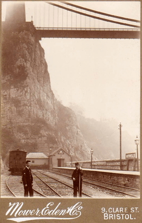
- Terminus: Clifton station, from March 1891 called Hotwells; zero point of the railway (6 March 1865 – 19 September 1921)
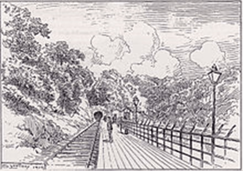
The terminus was next to the rocky promontory supporting the Gloucestershire pier of the Clifton Suspension Bridge, which had been officially opened on 8 December 1864, three months before the railway. The station served from 1 June 1885 as an interchange point with the city’s tram service 9 (and from 1917 also the 17) from the Tramways Centre.
Its buildings and structures were on raised and levelled ground with a retaining wall above the bank of the Avon and what was then known as Hotwell Road (which continued along the course of the present Bridge Valley Road). They consisted of a single platform which was eventually extended to 280ft in length; the station building with booking office and waiting room; and a short-lived refreshment room (later converted into more waiting space and offices). There was also a house intended for the foreman porter; a shed (burnt down in 1873); lineside bunkers; a small building close to the entrance of tunnel no. 1 (the water tank on a ? brick tower, https://www.britainfromabove.org.uk/en/image/EPW001274 (1920), apparently still there in 1973, OS 1:1250 plan, which is not borne out by earlier aerial photos); a lever box for the points; and two posts (? telegraph pole and ? signal post) mapped in 1884–5 (OS 1:500 map, both maps via Old-Maps, https://www.old-maps.co.uk; track and facilities diagram, Maggs 1975: 21).
The station had three roads: a platform road, a runaround loop and a carriage siding. There was a turntable serving all three roads, removed in about 1893, which had been installed so that the BPR&P’s tank engines could be turned to avoid bunker-first running (Vincent 1979: 3, 81, 129; Mitchell and Smith 2004: images 35–38).
Goods facilities were closed on 1 September 1890, and passenger traffic ceased on 19 September 1921.
“Midland Explorer Boy” reported in December 2010 that “no trace now remains” of Hotwells station, “other than one or two patterned stone tiles scattered at the base of the Suspension Bridge.” (https://www.flickr.com/photos/midlandexplorerboy/5268449584).

See also: https://maps.bristol.gov.uk/knowyourplace/images/her_pc/6468.jpg showing the retaining wall of the raised ground on which the station was built; and a Garratt postcard https://maps.bristol.gov.uk/knowyourplace/images/her_pc/13983.jpg showing steam from a standing loco.
There are excellent photos of trains at Hotwells station in Maggs (1975: 26‒27) and Maggs (2011: 20), and of the station generally in Oakley (1990: 55‒58).
- Hotwells tunnel no. 1, approx. 7-10 chains from zero
No. 1 (72yds, 66m long) is the shorter one closer to the Clifton Suspension Bridge. The tunnel was entered immediately on leaving Hotwells station. After abandonment in 1921 it was used from 1939 till about 1980 as a safe place – a “Bomb Proof Records Room” ‒ for the city archives and museum exhibits (MacInnes 1962: 30). The city archivist Elizabeth Ralph organized the transfer. The tunnel was divided into two levels, with the lower one given over to city officials’ emergency offices off a barrel-roofed corridor, and a toilet. The floor is now permanently flooded. Descriptions have been posted online by persons who have gained entry since 2000.
The rooms themselves are split into two levels, most of them are empty save for either metal or very rotten wooden racking, however the upper levels at the very end contain a number of beautiful rusty trunks which stored deeds and other important documents for the most important and influential people in the city. Some names were recognisable – Fry (chocolates) and Wills (tobacco) – and some boxes dated way back into the mid 1800s. (derelictplaces 2008; see also WhateversLeft 2020).
- No. 1 south portal

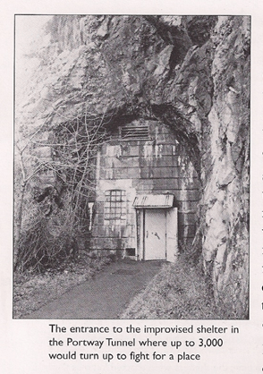
Clearly taken from a book or magazine – not known which. The printed caption is mistaken; this is not the air raid shelter, which was Tunnel no. 2.
(NB this portal is not of brick or dressed stone like the others, just cut into the rock; the tunnel itself is brick-lined.)
More images:
https://www.ebay.co.uk/itm/PHOTO-HOTWELLS-TUNNEL-1951-/363235789423
https://www.28dayslater.co.uk/threads/bomb-proof-record-rooms-july-2020.124152/
- No. 1 north portal
More images:
https://www.ebay.co.uk/itm/PHOTO-3-HOTWELLS-TUNNEL-IN-1951/224294739119?_trkparms=aid%3D1110006%26algo%3DHOMESPLICE.SIM%26ao%3D1%26asc%3D20200818143230%26meid%3D982d314b059e4385ad1203f14be2b772%26pid%3D101224%26rk%3D2%26rkt%3D5%26mehot%3Dnone%26sd%3D224294739116%26itm%3D224294739119%26pmt%3D0%26noa%3D1%26pg%3D2047675%26algv%3DDefaultOrganic&_trksid=p2047675.c101224.m-1 and http://archive.cliftonhotwells.org.uk/chis_news_archive2011.html

- Cutting of about 30yds/27.5m between the tunnels
- Hotwells tunnel no. 2, at 11-19 chains from zero
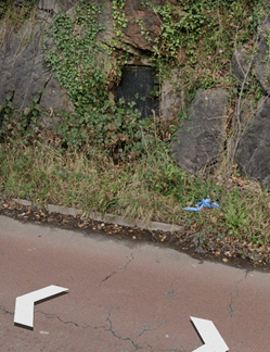
No. 2 (175yds, 160m; also called Portnall’s no. 1) goes through the rock spur supporting Bridge Valley Road and part of the former Zigzag Path. This is the longer tunnel. There is an emergency exit hewn through the rock, with a door giving onto the Portway, which may have served for ventilation when the tunnel was occupied.
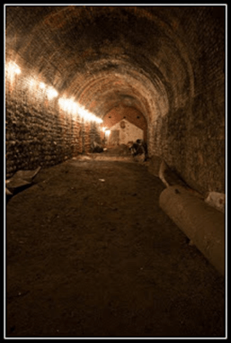
Nothing of consequence happened in or to the tunnel until long after the railway closed. People used it as an air raid shelter during WW II, mainly from late 1940 to mid-1941. The shelter seems to have been a mixed blessing. Many people felt it would be safer to go here than to their own Anderson shelters, simply because it was underground in apparently solid rock; however the northern end was geologically unstable and had been officially condemned. The nearer end was deemed at first to be suitable for 200 people, despite its serious defects as a place to live, however temporary (Horder 1940; MacInnes 1962: 95–98, who called it “this miserable Mecca” and the worst shelter in Bristol; Byrne 2021: 5–6). It was wet, cold, insanitary and underequipped for mass occupation. But it swiftly became so magnetic that in January 1941 the whole tunnel was occupied, and the city council adopted a deeply unpopular pass system to restrict the numbers occupying it during air raids down from the 2500–3000 mainly working-class people who turned up from all over Bristol. It was condemned by the Southwest Regional Commissioner for Civil Defence, Sir Hugh Jamieson Elles, in the following words, taken from a letter to a colleague [Sir George Gater] at the Ministry for Home Security [really Ministry of Supply?]: “…. after the turmoil was over, it was discovered that upwards of 1,500 persons had formed a sort of gypsy encampment in this undesirable place and had filled it with beds, little shelters and the most indescribable collection of junk of all sorts.“ This callous intervention from the top must have bolstered the authorities’ desire to clear it; the Medical Officer of Health, Dr Robert Parry, was fretting about a possible TB or other epidemic. About 800 people refused to move out at first, but were encouraged by police with truncheons. Eventually the southern end of the tunnel was improved with bunks and toilet facilities for about 400 (Maggs 1975: 22). Everyone was out by the end of April, after the worst of the Blitz, but some returned in dribs and drabs till 1944.
Mass-Observation reporters visited Bristol three times between 19 December 1940 and 2 April 1941, noted the sorry state of the shelter dwellers, including those in the tunnel, and found morale low. The Corporation commissioned its own report on morale, which disagreed. Mass-Obs, as quoted by Juliet Gardiner (2004: ch. 14), declared:
In Bristol an old railway tunnel that ran from the port was used by ‘men, women and children huddled together sleeping on mattresses, planks or straw. Some had corrugated iron sheets or pieces of sacking and canvas placed overhead to catch the water that dripped from the rocky roof of the tunnel. The air was thick with fumes of oil stoves, oil lamps and various odours of cooking food …. When the corporation employees opened the doors in the mornings the stench and fumes came from within like a fog. It was a picture of Dante’s Inferno. Many of the people were nervous wrecks. People stayed in the tunnel by day, afraid to lose their places. There was hardly any room between the rough beds. Some performed their natural functions alongside the beds. It was unbelievable that people could be driven by fear to endure such conditions.’
The effect of the war on displaced disadvantaged children in particular was highlighted in a paper detailing the experiences of the Bristol Child-Guidance Centre (Bodman 1941, as mentioned by Dawes 2016). Bodman estimated that 82% of the 3000 people living in the tunnel in early 1941 were suffering some kind of psychiatric illness, and only half were receiving any kind of treatment.
An arresting insider’s description of the tunnel’s rigours has also been posted online by anonymous blogger Just a Boy from Bristol [identified via Twitter as Michael Kelly], who used the shelter as a child in early 1941:
Despite Mr Lloyd’s assertions that ‘Jerry’ wouldn’t be back, Mum was taking no chances.
‘We have a place in the tunnel. We will be safe now.’
‘The tunnel’, was a 525 feet stretch that ran under Bridge Valley Road. It was part of the defunct Port and Pier Railway. Our ‘place’ was deep in the bowels of the Avon Gorge, at the rear of the tunnel. When we arrived on that first night, there were thousands clamouring to get in. The man on the door was very friendly, and waved us through with a smile, a nod, and a wink. As we entered, he patted my mother on her bum. I thought she might have been angry, but she smiled, and her nostrils flared. I decided that the man must have told her that she looked like Hedy Lamaar [sic].
[picture removed]
Inside, that tunnel was not a very pleasant place. It was dark, damp and very, very smelly. An official report [Lord Horder’s of 1940, RC] into the tunnel stated: ‘it deserved full marks for having everything that a shelter should not possess’.
The smell started as soon as you entered and became progressively worse as you made your way along. It was the first time I had witnessed our class structure in operation. The better off had their positions nearest the entrance, the middle classes were halfway up, and we peasants were at the back, where the stench was almost unbearable.
Another official report [not yet identified, RC; Bodman 1941?] stated:
‘A little over half way along, there is another brick wall. Beyond this the walls are whitewashed and bunks four across have been built. The poorest and dirtiest people of them all are using this end. The children are four to a bunk. Lighting is by candles and oil lamps. There is a brick wall with sackcloth; on the other side are closets labelled M and W. The closets are never empty for more than 30 seconds at a time; they serve over a thousand people. There is a stinking tang of chlorine.’
The German bombers came back in force on the night of December 2. The raid started at 16 minutes past 6 and lasted until 11 o’clock. 156 people killed, 149 seriously injured and 121 slightly injured. Redfield, Cotham, Redland, St Michael’s Hill, Welsh Back, Nelson Street, Portland Square, St Paul’s, Bridewell and Wills’ No. 1 factory were among the damaged areas. We heard the bombing, but only as dull, distant thuds. The Portway tunnel may have been a hell hole, but to our little ‘poor and dirty’ family, it was paradise. (2013)
This, and much more detailed reminiscence of the tunnel, can be found at http://kingsdownkid.blogspot.com/2013/06/just-boy-from-bristol.html; also at https://subsaga.com/bbc/documentaries/history/blitz-the-bombs-that-changed-britain/series-1/episode-4.html.
The city fathers’ attitude to the priorities of people seeking shelter can be gauged more subtly from another story. Also in 1941 this tunnel was proposed as a wartime home for the BBC Symphony Orchestra, as Gerald Daly, former engineer in charge, BBC West Region, recalled in 1974, apparently conflating the two tunnels in his memory:
The old railway tunnel where Bristol archives were kept seemed a likely place for the orchestra from the shelter point of view, but how would an orchestra sound in the narrow confines of a railway tunnel? We decided to try and Sir Adrian [Boult, RC] assembled about sixty players in the old tunnel. A record was made and to our amazement the musical quality was far better than expected. So we decided to put the matter to my bosses in London. The Director General, Mr (later Sir) Frederick Ogilvie, came down a week or two later and I took him through the length of the tunnel holding up an Aladdin paraffin lamp. Alas, however, there had been an unpleasant raid on Bristol and particularly Avonmouth (about six miles away) and the tunnel was crowded with refugees, so we could hardly move. The city authorities offered to get rid of them, but we could not take it and gave up the idea of using that tunnel. (Daly 1974).
The BBC eventually installed themselves in the nearby tunnel of the defunct Clifton Rocks Railway (Daly 1974; Shapland 2017). This is sometimes confused with the Portway tunnel, as it was in the BBC’s own handbook for 1973.
Tunnel no. 2 was built on a gentle curve. The section most nearly straight, nearer the city centre, was used as a shooting range by Bristol Gun Club after WW II. It shut down in 1996, anticipating the banning of all cartridge-ammunition handguns under the Firearms (Amendment) (No. 2) Act 1997.
the first third has been converted by the gun club, the central third exposes the original rail tunnel and the final third displays the shelter. (https://www.thetimechamber.co.uk/beta/sites/deep-shelters-air-raid-shelters/bridge-valley-road-deep-shelter-bristol, last modified 2017)
Some evidence of occupation was formerly visible, including corrugated iron sheeting of uncertain date (?wartime) forming walls and a peaked roof, material left behind by the Gun Club and a toilet compartment. It was still fully lit by electricity when entered in 2008. Some abandoned furniture remained in place till cleared.
The northern end of the tunnel (the one occupied by the poorest people in 1941) was, as noted above, geologically unstable. The whole tunnel was filled in in 2010/11 when Bridge Valley Road above it appeared likely to suffer landslip or subsidence damage. Descriptions have been posted online by persons who have gained entry since 2000, and the following is by CAN, the contractors responsible for stabilizing the road:
A disused rail tunnel that ran along the length of the site required waterproof tanking [using a slurry coating, RC] throughout. This prevented accidental leakage of the 2000m3 of grout which was then pumped to completely fill the void and stabilise the road above. (https://www.can.ltd.uk/casestudies/bridge-valley-road-stabilisation-works, 2011)
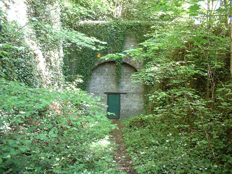
- No. 2 south portal
More images:
https://www.whateversleft.co.uk/underground/bridge-valley-road-deep-shelter-bristol, third image
- No. 2 north portal

More images:
https://www.derelictplaces.co.uk/threads/bridge-valley-road-deep-shelter-bristol-september-08.6930/, which also has other images (2008)
https://www.flickr.com/photos/midlandexplorerboy/5305616635, which also has other images (2010)
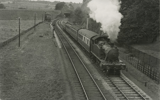
- Platform: Hotwells Halt, a.k.a. Hotwells Extension Platform (14 May 1917- 3 July 1922), at about 25 chains from zero; 1 mile 35 chains from Sneyd Park Junction
Hotwells Halt was established just north of tunnel no. 2 in 1917 as a relief platform because the longer trains demanded by wartime activities at Avonmouth docks could not fit into the Hotwells terminus. The rear carriages of trains from Avonmouth were positioned to disembark passengers here before the train moved on to discharge the front carriages at the terminus. Those who left the train at this halt had to walk the Avon-side road below the railway to get to the tram terminus.
This 700 ft long wooden platform is said to have been accompanied by a loop carriage siding (Maggs 1975: 23; Oakley 1990: 58), but no visual or map evidence has been found. There were two ticket booths, one dealing solely with tickets for Avonmouth.
There was a signal box at the northern end of the platform controlling access to the siding (Maggs 1975: 23; Vincent 1979: 81; Oakley 1990: 58).
- Bridge: Bramble Lane, near Bishop’s Knoll
The existing bridge over the Severn Beach line also spanned the Hotwells branch, as witness the “spare” arch across the overgrown trackbed, hard to pick out in the photo below. The arch is wide enough for the branch’s original short stretch of double track, which became single shortly after the bridge in the direction of Hotwells.

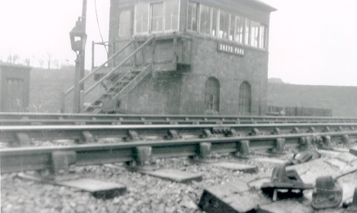
- Signal box: Sneyd Park (Junction), at 1 mile 60 chains from zero
This 20-lever box was opened in 1917. The line from here to Hotwells halt was operated by electric tablet, and from there to the terminus by a wooden staff (Vincent 1979: 81). The Sneyd Park Junction box controlled a signal in each direction a short distance along the line towards Hotwells (double track for a few chains) and one towards Avonmouth. Despite the closure of the Hotwells line in 1922 and the removal of the crossing rails on 27 July 1924, the signal box at the site of the junction remained in use till 26 May 1935, though with “Junction” removed from its name (Maggs 1975: 23; Rendall 2018: 78).
- Other survivals
No other relics of this section of the BPR&P are known to survive.
- The Portway
The new road (at first A36, now classed as an extension of the A4) bypassed the sites of the terminus, the tunnels and the halt before incorporating the old trackbed for hundreds of yards towards Avonmouth, obliterating any former traces between Bridge Valley Road and just beyond Black Rock. The site of the terminus was used by the contractors (Nott, Brodie Ltd) to store vehicles and materials.
End of article
- Resources
Archive items:
Bristol Archives: Papers relating to] Hotwells tunnel [when in use as a store by Bristol Record Office], catalogue reference 40482/Mgt/2.
Bristol Archives: [undated] plans and drawings, Portway tunnel, catalogue reference 42054.G.Drawer [three items].
Horder, Lord [Thomas] (1940, unpublished but often referenced) Air raid shelters: report upon conditions and use of air raid shelters with particular reference to health. London: Ministries of Health and Home Security.?] A brief reference to the use of tunnels can also be found in:
Horder, Lord [Thomas] (1941) The modern troglodyte. The Lancet 237, no. 6138 (19 April 1941), 499‒502 [at 499]: “In still another town, whose industry has completely disappeared, a disused railway tunnel had been converted into an underground street, and a mean street at that, and the tendency for the population to become residential was increasing. “Blitz” or no “blitz,” the children did not see the sun, or even the daylight, for days together, and the old and infirm came to the surface less often still.” https://www.sciencedirect.com/science/article/abs/pii/S0140673600578829#!, accessed 26 April 2021.
Mass-Observation archive, formerly at the University of Sussex, now at The Keep, Brighton: Topic Collection 66, box 3 (BRISTOL 1940-41 ….); referenced https://www.sussex.ac.uk/library/speccoll/collection_catalogues/tclists/tc66.html; replaced by https://www.thekeep.info/collections/ ….
— 66/3/A, Nov/Dec 1940: includes: Handwritten report: Hot Wells Tunnel (air raid shelter), 17‒18 December 1940.
— 66/3/B, Jan‒Mar 1941: includes: Handwritten reports: shelters (including Hot Wells Tunnel). …. 18-page handwritten report covering morale, Hot Wells Tunnel (Clifton), …. shelters in general including plan of a shelter, 28‒29 January 1941; also one-page summary of report, 5 March 1941.
The National Archives: Underground accommodation: old railway tunnel, Portway, Bristol, catalogue reference https://discovery.nationalarchives.gov.uk/details/r/C11444905 (with photographs; 12 April 1952 – 18 February 1953).
Paper documents and publications:
Bodman, Frank H. (1941) Enemy action. In The future of child guidance in relation to war experience. London: The Child Guidance Council, 1–7.
Byrne, Eugene (2021) Harsh winter of constant warnings and frequent attacks took toll on everyone. Bristol Times (6 April), 4–6.
Daly, Gerald (1974) Letter to Patrick Handscombe about the Clifton Rocks Railway Tunnel. Reproduced, slightly edited, at http://www.orbem.co.uk/clifton/clifton.htm.
Dawes, Laura (2016) Fighting fit: the wartime battle for Britain’s health. London: Weidenfeld and Nicolson. [E-book edition consulted.]
Elles, [Sir] Hugh Jamieson (1941) Letter to Sir George Gater, quoted in https://subsaga.com/bbc/documentaries/history/blitz-the-bombs-that-changed-britain/series-1/episode-4.html. [This video also contains testimony from Ralph and Gerald Smith, children using the tunnel. Gerald recalled: “We got down to the tunnel and there must have been about 700 or 800 people. It was absolute chaos. It was terrible and everybody was fighting for places. You couldn’t lay out, so you had to kneel, cooped up with your back against the wall and it was always streaming with water.”]
Gardiner, Juliet (2004) Wartime: Britain 1939-1945. London: Headline. [E-book edition consulted.]
Horder, Lord [Thomas] (1941) The modern troglodyte. The Lancet 237, no. 6138 (19 April 1941), 499‒502 [at 499]. Online, https://www.sciencedirect.com/science/article/abs/pii/S0140673600578829#!, accessed 26 April 2021.
MacInnes, Charles M. (1962) Bristol at war. London: Museum Press. Online, http://www.bris.ac.uk/Depts/History/bristolrecordsociety/publications/macinneswar.pdf.
Maggs, Colin G. (undated; 1975) The Bristol Port Railway & Pier and the Clifton Extension Railway. The Oakwood Library of Railway History 37. Tarrant Hinton: Oakwood Press.
Maggs, Colin G. (2011) Bristol and Bath railways in the Age of Steam. Newbury: Countryside Books.
Mitchell, Vic, and Keith Smith (2004) Branch lines around Avonmouth. Midhurst: Middleton Press.
Oakley, Mike (1990) Bristol suburban. Temple Meads, local station, halts and platforms, 1840-1990. Bristol: Redcliffe Press. New edition (2006) Bristol railway stations, 1840-2005.
Rendall, P. D. (2018) The Avonmouth line: history and working. Ramsbury: Crowood Press.
Shapland, Maggie (2017) The ups and down of the Clifton Rocks Railway and the Clifton Spa: the definitive history. Bristol: Clifton Rocks Railway.
Vincent, Mike (1979) Lines to Avonmouth. Oxford: Oxford Publishing Co.
Web resources:
- Image galleries:
Bridge Valley Road Deep Shelter, Bristol
https://www.28dayslater.co.uk/threads/bridge-valley-road-shelter-bristol-aug-2008.122825/
https://www.28dayslater.co.uk/threads/bridge-valley-road-air-raid-shelter-bristol-24-08-08.34268/
https://www.28dayslater.co.uk/threads/bridge-valley-road-air-raid-shelter-bristol-march-2010.49017/
https://omm.gothick.org.uk/wanders/66
- Image galleries with some text:
http://www.forgottenrelics.co.uk/tunnels/gallery/portway.html
http://www.mark-davis-photography.com/explore/bridge-valley-road-deep-shelter-bristol/
https://www.derelictplaces.co.uk/threads/bridge-valley-road-deep-shelter-bristol-september-08.6930/

*
All web resources cited were accessed, and found safe, between 8 April and 4 May 2021. If any copyright has been inadvertently breached, contact the author at richard.coates@uwe.ac.uk and things will be put right.
